RESILIENCE + THE BEACH
Developed by: Sasaki/Rutgers/Arup
Location: Jersey Shore, NJ
Finalist Project
The team’s research and design strategies focus on the value of “the beach,” a place of special significance to memory, state and local economies, and a vital component of coastal ecosystems. New Jersey’s northern shore is an ideal place to study the identity and function of the beach, since it includes the three coastal typologies found across the eastern seaboard of the United States: Barrier Island, Headlands, and Inland Bay. Over the past century, Jersey Shore tourism has evolved to play a significant role in the state’s economy and in regional cultural identity. Yet, tourism practices have also impacted the ecology and resiliency of the beach and shore communities.
The shore’s relevancy and position is deeper than the narrow strand of sand where the ocean waves fall, the beach. In New Jersey, sandy soils extend inland to the expansive, ecologically rich pine forests (the Pine Barrens). Twenty two coastal lakes and myriad rivers and creeks extend estuarine and wetlands environments inland miles from the coast. Ultimately, the Jersey Shore’s future resiliency must be linked to projects that deepen the physical extent, ecological reach, and cultural understanding of the beach.
The Sasaki team has two approaches to resiliency for the Jersey shore
1) A regional program for the Shore, building on the strategic strengths of each community and developing collaborations spanning from Barnegat Bay to Raritan Bay; and
2) Local interventions in three sites that will serve as replicable “pilot” solutions.
The pilot sites represent the three coastal typologies. The Barrier Island strategy is tested in Berkeley Township, Toms River Township, and Seaside Heights. Asbury Park represents the Headlands condition. Finally, Keansburg, Union Beach, and Hazlet provide a pilot site for Inland Bay.
Barrier Islands
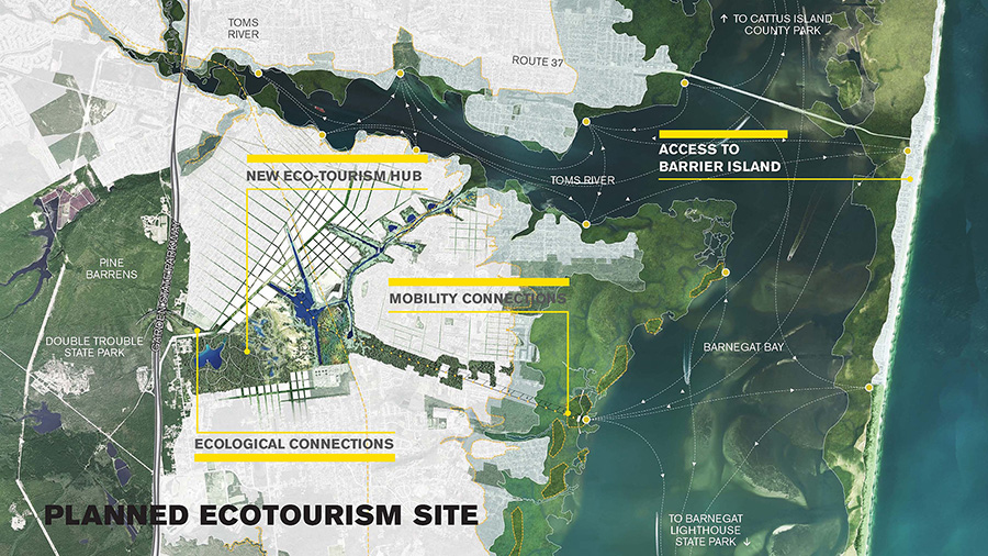
Nationally as well as along the famed Jersey Shore, barrier islands are the most vulnerable coastal condition, and the most central to a traditional notion of beach tourism and culture. The Barrier Island project diversifies the traditional beach economy, allowing the economic, social, and ecological health of communities to evolve as the environment of the shore shifts and changes. Identifying a series of high-and-dry nodes with greater access to regional transportation systems and a broader terrain for year-round eco-tourism, the project provides a new, more resilient choice for the beachgoer.
The case study for this approach is a node of underutilized land near Berkeley Town Center. Strategically located at the confluence of multiple transportation systems – including the Garden State Parkway, the Barnegat Branch Trail, and the navigable Mill Creek – the site allows for broader interaction with New Jersey’s extensive Pineland landscape to the west and a changing shoreline to the east. Proposed development includes new tourist accommodations, such as eco-lodges, cabins, and camp sites, as well as 5,000 new housing units for permanent and seasonal residents. A civic zone with resiliency center, as well as public education and entertainment programs, connects via the aerial tram system with new marinas and a water taxi hub on Barnegat Bay. The design of the Berkeley Town Center extension intersects directly with a layered zone of active recreation and a funscape evoking reinterpretation of the classic beach experience, integrating development with ecological zones with varying levels of accessibility.
Headlands
The headlands are the highest, driest, and least vulnerable of coastal edge typologies. They are characterized by large, linear ocean frontage areas, small communities with well-formed urban cores, access to public transportation, and a network of coastal lakes. Although headland communities offer the potential for less vulnerable, higher density development, they also struggle with water management challenges, a relative absence of ecological resilience, and socially vulnerable populations. The Headlands project introduces a series of layered strategies with integrated social and ecological components to address these challenges.
The case study is Asbury Park, a community known for its diverse cultural history, its memorable and iconic beach, and its series of significant coastal lakes. Today, Asbury Park’s boardwalk, streets, and coastal lakes share a common trait: each exists merely as infrastructure with hard edges, rather than as healthy ecosystems. To address the complexity of the community, our approach integrates three design projects to provide protection from the ocean, create inland protection from improvements to coastal lakes and streets, and connect the beach to the community. A new hybrid boardwalk-dune infrastructure along the oceanfront honors the social function of the boardwalk while redesigning it to create dunes within its edges that can protect the development behind it. Softening of the coastal lake edges helps to increase stormwater management function, ecological habitat, and recreation activities. The creation of green,hyper-absorbent streets cleans and manages stormwater through the community as it flows to the coastal lakes.
The boardwalk, as a case study, offers an opportunity to rethink the existing beach edge that today is a relative monoculture. A more organic boardwalk form and topography can create a new relationship to beachside development and promote an ecologically healthier landscape. The design of the boardwalk expands social interaction through the creation of seating, steps, and intimate edges while providing a new shape to capture sand and form dunes over time, creating protection and habitat area for beach wildlife.
Two different boardwalk conditions are explored – the civic core and the experimental zone. The civic core boardwalk enables the preservation of Asbury Park’s open bathing beach. At the same time, new terraces along its edge introduce a higher level of surge protection, more social space, and areas of extensive beach grass planting. The experimental zone exists north of the convention center and south of the casino. Wide expanses of beach and the absence of an existing boardwalk allow for implementing experimental dune/habitat creation strategies. The scale of dune creation in these areas will enable the protection of the wastewater treatment facility and help create a new park space that links to Deal Lake. The area between the boardwalk and water includes a series of sacrificial forming dunes, tidal pools, and a primary dune. The boardwalk form in both conditions takes its design cues from the existing boardwalk’s unique wooden herringbone pattern and the wooden sand fences that are used to structure dunes.
Inalnd Bay
As the most complex region of the Jersey Shore, inland bay communities are characterized by densely-populated maritime communities, increasing levels of integration into the Greater New York City economy, and a rich yet contaminated estuarine environment. Inland bay communities live every day with the water, both due to their historic dependence on maritime industry and their extensive relationship to a series of degraded creeks and marshes. Communities along the inland bay are susceptible to both storm surge and inland flooding. Our project seeks to reclaim the inland bay’s underutilized water spaces as public places, allowing for habitat migration, increasing recreational opportunities, integrating water management, expanding ecological education, and improving water quality. The project reimagines the waterways of the inland bay as new public space, providing recreation, as well as ecological and economic benefit.
Our case study explores the Natco Lake area and its relationship to adjacent communities (Keansburg, Hazlet, and Union Beach). Here, a series of cuts and dredging operations along the creek and lake landscapes create new marsh and wetland landscapes to embrace migrating species displaced by sea level rise. Dredge and cut materials are then used to create new protective measures along the coast, providing suitable redevelopment spaces along super levees in places undermined by Sandy’s storm surge.
Download a PDF of the team’s final competition boards here.
View a PDF of the team’s full proposal here.