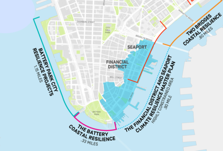
City Limits: Stand along the East River waterfront in the Financial District, and it quickly becomes how big a task City Hall has set for itself in protecting lower Manhattan from sea level rise. Manhattan’s southern tip is ringed by low-lying land — appropriate for an island that was significantly expanded in its early days by landfill on “water lots”— and its shoreline is a motley assemblage ofpiers, highway stanchions, and Department of Sanitation and Con Ed facilities that reflect the river’s history as a working waterfront and present as an attraction for tourists and locals alike.
In recent weeks, amid the vastness of the lower Manhattan waterfront, a tiny speck of a folding table has appeared on Fridays along the river, staffed by a few city officials seeking to explain City Hall’s multi-billion-dollar plans to create a complex network of flip-up flood gates, earthen berms, and other mechanisms to prevent a repeat of the catastrophic flooding that accompanied Superstorm Sandy in 2012. Following reaction to the $10 billion price tag attached to Mayor Bill de Blasio’s announcement last March of plans to add more than 50 acres of new land in the East River around South Street Seaport, as well as continuing uproar over the city’s plans to bulldoze and rebuildEast River Park, city officials are taking pains to stress that they’re aiming for a bespoke plan that will stave off future storm surges without unnecessarily inconveniencing New Yorkers.
“Community engagement is extremely critical to all of the projects,” says Jainey Bavishi, director of the city’s Office of Recovery and Resiliency. “We’re hosting public meetings on a regular basis, and are happy to meet with whoever is interested on any of these projects to make sure that they’re informed about the status and extent.”
But while construction on the first phase of the project, the southern section of Battery Park City, is expected to begin by the end of next year, the most difficult and contentious section — the nearly mile-long stretch between Brooklyn Bridge and Battery Park — remains up in the air in terms of planning, timeline, and funding, with a master plan only first set to be released in 2021. What the ultimate flood protection measures there will look like, and how much they’ll cost and who’ll pay for them, likely won’t be resolved until there’s a new administration in the White House, and likely City Hall as well. Read more>>

 Follow Us on Twitter
 Subscribe to Rebuild on
